
FAQs
What is the N22 Farranfore to Killarney project?
The N22 Farranfore to Killarney Project involves the examination of feasible transport solutions to alleviate existing capacity, safety and connectivity issues that exist on the national road network between Killarney and Farranfore and it surrounds.
Why is the scheme needed?
Improved safety needed: Traffic volumes are increasing on the road network and this has led to increased collision and safety issues. The current level of collisions on the existing road is high for the level of traffic observed, with the rate of collisions being twice the national average along sections of the existing road.
Poor connectivity: Improvements are needed to the transport connectivity between Tralee and Cork and between key towns along this route. Improved inter-urban connectivity is needed between Farranfore and Killarney.
Lengthy journey times: The current road network does not provide the level of service that is normally expected from a National Road. Journeys result in congestion issues for the majority of the population between Tralee and Killarney.
What are the benefits?
The project will seek to improve road safety on the existing routes, while also delivering better journey times and reliability for motorists and enhancing opportunities for investment through an improved road network.
Improved safety: If a road based solution is selected the project will increase the safety of the N22 Farranfore to Killarney road for all users in line with the Road Safety Authority’s Road Safety Strategy. It will provide a safer route for all road users and potentially reduce the frequency and severity of collisions. If a road based solution is selected the project aims to provide safer overtaking opportunities along the route, refine the number of junctions and thereby conflict points, and improve safety for vulnerable road users, such as pedestrians and cyclists, by providing a better road environment for this group of road users.
Enhanced connectivity: In line with Government policy, the project will support regional and rural connectivity, thereby strengthening economies and communities. The journey times between Farranfore and Killarney will be improved. This will strengthen the ‘Tralee – Killarney – Killorglin’ economic hub and encourage future growth and investment within the county.
Improved accessibility: The Scheme aims to reduce the congestion in the approaches to Farranfore and Killarney. This will allow greater accessibility for visitor and for local residents.
What is Jacobs role in this Scheme?
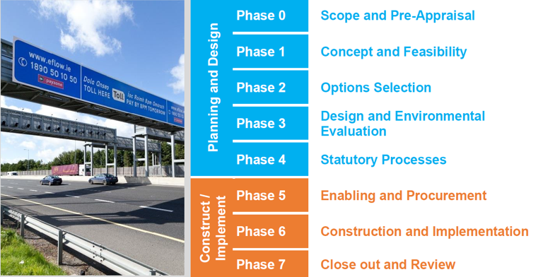
The management of the delivery of National Roads projects is divided into an eight-phase process (Phase 0 to Phase 7 inclusive) as illustrated in Figure 1 below. Jacobs have been commissioned for Phases 1 – 4 of the N2 Farranfore to Killarney Project We are currently in Phase 2 (Option Selection) of the Planning and Design stage and will progress towards a planning application.
Jacobs are working toward completing Phases 1 – 4 and there are a number of stages involved in developing the design such as:
Consult with members of the public and interested stakeholders on the constraints and Route Corridor Options (2021)
Identify an Emerging Preferred Route Corridor option 2022) Publish the Preferred Route Corridor for public display (2022)
Engage with stakeholders and landowners prior to submitting a planning application (2022 – 2024)
An Oral Hearing with An Bord Pleanála is expected to take place in 2025.
If the scheme is successfully brought through the oral hearing phase, the scheme can advance to Phase 5 and onward.
Our project consultation roadmap outlines these stages and the non-statutory public consultation periods which will accompany them. More detail can be found on the project website.
How can I contribute to the design of the scheme? / How can I have my say?
Public Consultation 1: The first public consultation will take place in Q1/Q2 2021, where your feedback is sought on any unidentified constraints within the Study Area. The consultation will inform you of the different stages of the assessment process and likely timelines. It will then provide detail of the Route Corridor Options developed, to which your feedback and comments will be sought. It will also be an opportunity for you to engage with the Project Team who can answer any questions you may have.
Public Consultation 2: The second public consultation will take place in Q4 2022, where the Project Team will present an Emerging Preferred Route Corridor (EPRC) chosen from the options presented at Public Consultation 1. The team will consider feedback and submissions from this non-statutory public consultation with respect to the EPRC and this feedback will form part of the final Route Selection Report.
Public Consultation 3: A third period of public consultation scheduled to begin in Q1/Q2 2024 will be undertaken as part of the planning application to An Bord Pleanála.
While the periods of public consultation are opportunities to make a submission or give feedback in the form of a submission, you can gain up to date information and provide submissions via the project website, email or phone line.
Email: info@n22kerrycountycouncil.com
Phone: 066 7183583
I have some environmental concerns about the development, how and who do I raise these with?
There are defined periods of public consultation throughout the Scheme when you will have an opportunity to give feedback on environmental concerns. In addition, there is a dedicated project email and phoneline for any queries you may have. You can contact the team by phone or email at;
Email: info@n22kerrycountycouncil.com
Phone: 066 7183583
Will environmental concerns be considered?
Yes, environmental constraints will be identified through our constraints mapping as part of the statutory process to bring a project to planning. Environmental consultants will be involved throughout each stage of the project in order to identify and protect designated sites. Ecological surveys will take place and findings from these will feed into the Emerging Preferred Route Corridor option for the project. The findings will be published in the Environmental Impact Assessment Report (EIAR), which will be submitted to An Bord Pleanála along with our planning application.
What is an Environmental Impact Assessment Report?
An Environmental Impact Assessment Report (EIAR) is a report that contains detailed analysis of the potential impacts of a proposed project on the existing environment and includes sufficient information to allow, in this case, An Bord Pleanála to make a decision on whether a planning application should be granted for the scheme.
The EIAR will present a description of the existing environment, an assessment of the potential impacts of the scheme, will set out measures to avoid or mitigate against any adverse impacts and identify any remaining residual effects. The impacts will be assessed and presented in line with the environmental topics under the EIA Directive 2014/52/EU. Work for this, including environmental surveying, is expected to begin in 2021/2022 and the environmental team will work towards issuing an EIAR to An Bord Pleanála in 2024.
An Oral Hearing with An Bord Pleanála is expected to take place in 2025. The purpose of an oral hearing is to allow further discussion and examination of relevant issues that may arise in a case before An Bord Pleanála.
How will the scheme be funded?
The N22 Farranfore to Killarney Project has been identified as a priority within a list of key projects in the National Planning Framework and the National Development Plan. The Scheme is subject to ongoing funding and statutory approvals including the Department of Public Expenditure’s Public Spending Code and the Department of Transport’s Common Appraisal Framework for Transport Projects and Programmes.
Will this project go ahead with possible funding issues in relation to the economic challenges faced with the ongoing pandemic?
The N22 Farranfore to Killarney Project has been identified in the Trans-European Transport Network (TEN-T), National Planning Framework – Project Ireland 2040, National Development Plan 2018 – 2027, Regional Spatial and Economic Strategy for the Southern Region (RSES), Kerry County Development Plan, 2015-2021 and the Killarney Municipal District Local Area Plan (LAP) 2018 – 2024. Improvements to the N22 Farranfore to Killarney Project would align with current policy at European, National, Regional and Local levels. There are several specific references at a National and Regional level to investment in new offline road infrastructure to upgrade the route and to provide new connecting routes to the N72 and N71.
Kerry County Council have been advised by Transport Infrastructure Ireland (TII), along with Jacobs Engineering Ireland consulting engineers to take the project through the planning stages from Feasibility Stage. The scheme will however be subject to ongoing approvals and reviews throughout the planning process through a series of gateway approvals.
What is the history of this Scheme?
In 2003, a Preferred Route Corridor for an improved section of the N22 National Primary road between Farranfore and Killarney was identified. Following a Peer Review process in 2008, some refinement areas were identified for re-assessment and a refined Preferred Route Corridor was finalised in 2012. However, this project was later suspended due to the economic downturn. Since
the identification and appraisal of the refined Preferred Route Corridor for the N22 Farranfore to Killarney Road Improvement Scheme, a number of changes to road infrastructure, European/National policy and project appraisal have occurred. These include:
Publication of the Department of Public Expenditure and Reform (DPER) Public Spending Code
Updating of the Department of Transport, Tourism and Sport (DTTaS) Common Appraisal Framework (March 2016)
Updating of Transport Infrastructure Ireland (TII) Project Appraisal Guidelines (Oct 2016)
- Updated TII Project Management Guidelines 2017
- EIA Directive 2014/52/Eu)
- Guidelines for Ecological Impact Assessment in the UK and Ireland; Terrestrial, Freshwater, Coastal and Marine (CIEEM, 2019);
- Guidelines for Landscape and Visual Impact Assessment. Third edition. (Landscape Institute and the IEMA 2013;
- Guidelines on the Information to be Contained in Environmental Impact Assessment Reports (EPA 2017)
Kerry County Council have now been advised by Transport Infrastructure Ireland (TII) to revisit the appraisal process from Feasibility Stage and assess all alternative options, along with Jacobs Engineering Ireland consulting engineers taking the project through the planning stages.
What public transportation solutions are you studying?
We will consider enhancement, extension, or provision of public transport services or public transport infrastructure. When developing options for assessment there is merit and need to consider a ‘Do-Something Public Transport’ option.
If you provide all the proposed public transport you are studying, why do you need to build a new road?
A public transport-based option on its own, similar to road-based options, would be developed in an incremental manner as a means of determining whether public transport in and of itself would resolve the identified transportation issues.
What does a road-based route corridor represent?
Route corridors on this project will typically be 400m in width. Route corridors do not represent the actual width of the road scheme or lands to be acquired. The corridors give an indication of the area within which it is intended to develop a road alignment. In some instances, the route corridor may be increased at particular locations or may change, typically to accommodate engineering needs, environmental assessments or to address feedback provided through the consultation processes.
Can a road-based route corridor change?
Feedback obtained from the public consultation and ongoing surveys and environmental/engineering assessments will be considered by the Project Team and, if appropriate, route corridors may be adjusted. Route corridors are typically shown 400m in width to allow for adjustments to route options as described above. The adjustments to the route alignment options will generally occur within the route corridor but in some instances the route corridor may need to be increased or changed. Combinations of different sections of route corridor options may also be examined if it is thought that such combinations of sections could result in a better overall scheme.
How is the Emerging Preferred Route Corridor identified?
During the route selection process, several route corridors are developed taking account of the constraints. A quantitative analysis is then undertaken to measure the potential impacts of each of the route corridors options against the following criteria:
Economy Engineering Environment
The remaining route corridor options will be displayed at the first non-statutory public consultation in Q1/Q2 of 2021. The route corridor options can be further refined following public feedback, and the then re-assessed in greater detail using the 6 assessment criteria listed below to identify an ‘Emerging Preferred Route Corridor’.
- Economy Safety Environment
- Accessibility & Social Inclusion Integration
- Physical Activity
An Emerging Preferred Route Corridor is the Route Corridor Option that has been assessed as providing the optimum combination of benefits and impacts with regards to criteria outlined above. During Stage 3 of the Route Selection Process, the Emerging Preferred Route Corridor will be reviewed, refined and confirmed to establish the Preferred Route Corridor.
Will the schemes involve demolition of property?
Due to the anticipated size of the N22 Farranfore to Killarney Project it is likely that some residential/business property will be affected, and it is possible that a small proportion may need to be purchased to facilitate the project. Each property is considered a constraint and in so far as possible, the scheme will seek to avoid and/ or minimise impacts. If property acquisition is required to facilitate the scheme, affected property owners will be consulted directly by the Project Team as the design of the project develops.
How will land be acquired? Will I be compensated?
Given the scale of the project, it is likely that all lands required for the schemes will be acquired through a Compulsory Purchase Order (CPO). Should any part of a person’s private land/ property holding be included in the CPO, the land/property owner is entitled to compensation. This may also be the case for a person who may have an interest in any land/ property identified in the CPO. Compensation will be provided in accordance with CPO legislation. A guide to the process and the legislation is provided by the Citizens Information (https://www.citizensinformation.ie/en/housing/losing_your_home/compulsory_purchase_and_compensation.html)
How can I get further information?
We are available to answer any questions you may have, and you can contact us directly through this website in the contact us section, or by any of the following; project email, project phoneline and postal address.
We will provide updates here on the project website https://n22.kerrycoco.ie/. Here you can find relevant contact information and updated project information as the project progress, as well as information on how you can contact us or make a submission on our proposals via email info@n22kerrycountycouncil.com or phone 066 7183583.
What is happening now?
We are currently working on Phase 2 Stage 1. The project Phases are illustrated below.
To date, a Constraints Study has been carried out to identify all off the constraints within the study area. Several feasible Transport Option have been developed, and which minimise impacts on these constraints. We are currently assessing the impacts of each of these Transport Options with a view to selecting the Transport options that will be taken forward to the Phase 2 Stage 2 assessment process.
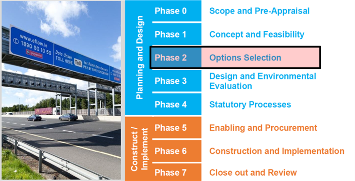
Figure 2 Current Project Phase from the Project Management Guidelines
From May 14th to June 25th 2021, the first non-statutory public consultation occurred, which focused on the constraints study mentioned and the recommended Transport Options. It provided an opportunity to explain the future assessment process, it’s roadmap and associated public consultation and engagement.
A non-statutory public consultation period for the N22 Farranfore to Killarney Project is now closed. The next Public Consultation period is due to open in Q4 2022 when it is expected that the Emerging Preferred Corridor will be selected.
When will construction begin and how long will it take?
Jacobs have been commissioned to bring the scheme through the planning stage from Phases 1 – 4. We are currently working on Phase 2. We expect Phase 4 to be completed following the Oral Hearing with An Bord Pleanála which is planned to take place in 2025.
If the scheme is successfully brought through the oral hearing phase the scheme can advance to Phase 5. The timing for Phases 5 and beyond will be dependent on exchequer funding and government policies. However, securing land and completing advanced works such as Archaeology and Site Investigation Contracts and further developing and completing the procurement process can typically take two to three years during Phase 5. Once the construction phase begins, Phase 6, the team envisages that construction could typically take around three years to complete once the Contract is awarded.
Why is it taking so long for construction to begin, what is happening between now and construction starting?
Although a Preferred Route Corridor was finalised in 2012, due to the suspension of the project caused by the economic downturn Kerry County Council have been advised by Transport Infrastructure Ireland (TII) to revisit the appraisal process from Feasibility Stage and assess all alternative options, along with Jacobs Engineering Ireland consulting engineers taking the project through the planning stages because there have been a number of changes to road infrastructure, European/National policy and project appraisal have occurred. These include:
- Publication of the Department of Public Expenditure and Reform (DPER) Public Spending Code
- Updating of the Department of Transport, Tourism and Sport (DTTaS) Common Appraisal Framework (March 2016)
- Updating of Transport Infrastructure Ireland (TII) Project Appraisal Guidelines (Oct 2016)
Jacobs, on behalf of Kerry County Council are now revisiting the appraisal process and assessing all alternative options to take the Project through the planning process. This involves constraints mapping, options selection, and route appraisal. Then, subject to
Government approval, a planning application will be made. If planning permission is granted, and sufficient funding is available, the procurement of contractors and construction will follow on from this decision.
Is the previous displayed route corridor available as I wish to apply for planning and live adjacent to this?
Kerry County Council are required to protect the corridor shown in the development plan. However, as we have re-commenced the option selection process, all planning applications will be assessed on a case by case basis by the project team and planning department within the Council. Upon completion of the current option selection process, the preferred route will be considered by the Elected Members for inclusion within the Development Plan.
Will this project affect the planning application process in the area?
Kerry County Council Planning Department have the responsibility for planning and managing development within the County. New planning applications within the study area may have an impact on the delivery of a future scheme. Planning applications and new developments may still be granted within the study area/route corridors, however as some planning applications may affect the scheme all relevant planning applications will be reviewed by the design team. Each application will be considered on a case by case basis and a considered engineering opinion will be formed in relation to the potential impact of the application on the scheme. In some cases an application may be considered premature subject to the preferred route corridor being determined.
What will the status of bypassed sections of national roads be post completion if a road-based option is considered?
The status of bypassed sections of national road has not been determined at this time. Bypassed sections of national roads may remain as a national road or may be reclassified to regional or local roads following construction of new sections of the national route.
If I miss the deadline for submitting email/phone queries or feedback on the public consultation, can I still make my views known?
In order to consider all feedback received and prepare a post-consultation report, we would ask that all feedback forms (online or postal) be submitted before 5pm on Friday June 25th 2021
General queries can continue to be made after this time via email, post and phone at the contact details provided on the website.